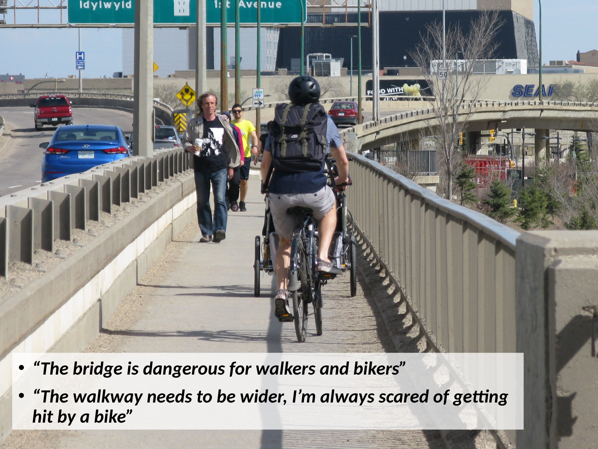
The City Standing Policy Committee on Transportation meets on Monday at 2:00 in Council Chambers. Early on the agenda are Warrick Baijius and Cam McMillan from Walking Saskatoon giving a presentation on proposed upgrades to the Idylwyld Bridge walkway. Come down to the meeting to show your support or watch the livestream broadcast.
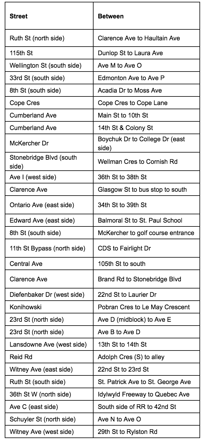
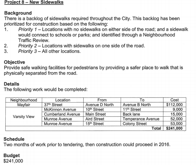
The following streets will get sidewalks this year where none existed before (as long as council agrees to spend already budgeted money):
Some very high-profile problem blocks will get much needed sidewalks:
Cumberland from 14th to Colony, a major thoroughfare for University commuters and home to a mud-and-snow-bound bus stop:
How about Clarence from Brand to Stonebridge Blvd? A new suburb designed to fix the mistakes of past neighbourhood efforts with regards to walkability but where they forgot to put sidewalks on many major roads?
As we discussed during last year’s release of the list the budget line item for sidewalk infill has no ongoing funding attached, but rather relies on year-to-year one-time allocations. Last year, red-light camera fine money was used. This year saw ten times the money spent ($2.3M vs $240k) as federal money from the Public Transit Infrastructure Fund was used this year.
This led to some changes for the criteria used to select streets to construct sidewalks on. Last year, there was a formula used that incorporated access to parks and schools. This year, access to bus stops was used as the primary criterion given the transit-focused funding source.
Next year, the fight for funding begins again. Walking Saskatoon will be heavily lobbying on the issue, as well as pushing for more transparency in the judging criteria and list of streets that are under consideration for sidewalk infill. However, this year is the most successful ever for infill sidewalk construction in city history and both council and administration are to be commended for their attention to this issue.
Many may have seen Streetsblog’s Sorriest Bus Stop in America contest. Given our city’s too-large collection of sidewalks that start and/or end nowhere in a similarly useless fashion to a bus stop on an Interstate, we are interested in your pictures of stranded sidewalks in Saskatoon. Use the hashtag #sidewhere and/or send it our way via Twitter or Facebook using the links at the left.
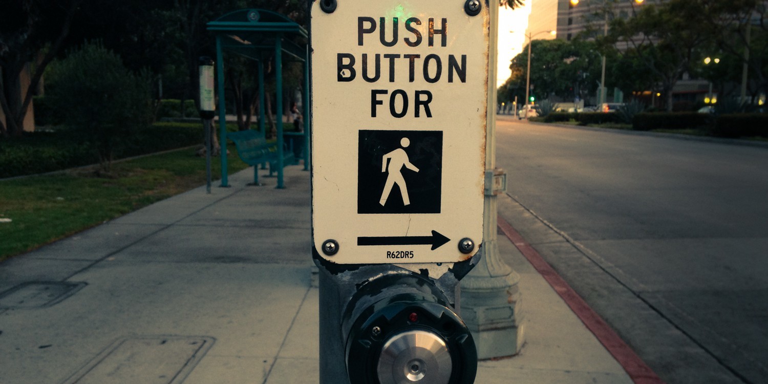
We’ve probably all encountered this scenario: you arrive at an intersection on foot and see a green light for the direction you want to cross but the ‘do not go’ hand is up. Do you cross? It seems fine, but in the back of your mind is the worry that you are encountering some esoteric traffic setup that is going to result in you being stranded in the middle of the road in the best case scenario. Of course, in the worst case scenario you are risking getting t-boned by a car. It’s also actually illegal to cross as a pedestrian when you don’t have the signal (or if you start crossing during the countdown timer!)
Why is there this signalling mismatch between pedestrians and cars? The reason is ‘beg buttons’, where pedestrians need to hit the button to not only get the walk signal but to extend the amount of time available to cross to street to a reasonable length.
Why are beg buttons terrible?
No one knows how they work! You can stand at any reasonably trafficked intersection and see how pedestrians treat these buttons. Some hit them, some don’t, and if you took an informal poll probably one of out ten people could tell you exactly what these buttons do. Additionally, most lights downtown don’t require using the button to get the walk signal but the majority of signals in the rest of city do, with no way to tell them apart.
They are explicitly anti-pedestrian. If you miss hitting the button by any amount of time before the crossing window, the walk light will not come on. This causes a double-cycle wait for anyone trying to cross the street on foot. Combine this with the lack of consideration for pedestrian wait times in traffic plans and you can easily have several-minute delays trying to cross (see College Drive for an example)
Add a lack of knowledge about how the buttons work, complicated traffic patterns and long delays in crossing time and you get very unsafe conditions. Five Corners on Broadway, one of the busiest pedestrian intersections in the city and one that is also adjacent to a K-8 school, resembles a game of Simon Says in terms of the complexity of crossing patterns.
Beg buttons probably have a place on streets with lower pedestrian traffic but for corridors with heavy pedestrian traffic (Broadway, Downtown, College Drive, etc..) they should be eliminated and pedestrians should be able to count on consistent crossing lights and times. Edmonton is already in the process of doing this, recommending in three separate reports for either the full elimination of beg lights or, at the least, their elimination on major shopping corridors.
Reducing the use of beg buttons is an easy and cheap fix to improve pedestrian safety and neighbourhood walkability that Saskatoon should look into doing in short order. Please contact your city councillor and let them know how you feel.
Walking Saskatoon and the Buena Vista Community Association met with Councillor Cynthia Block and the Department of Transportation’s Jay Magus to discuss widening the Sid Buckwold Bridge’s pedestrian walkway a couple of weeks ago. We delivered this presentation and the City was kind enough to provide this presentation with costing and designs for the new walkway.
We plan to present a proposal to city council sometime this summer to try and get the project funded. Stay tuned for more updates or get in contact if you have any questions or feedback on the city’s plan.
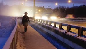
Pedestrian/cyclist crossing on the Sid Buckwold bridge is a disaster. The existing walkway on the north side of the bridge is too small and too exposed. Stories abound about near misses from protruding lumber pieces on trucks or debris kicked up from the road, and getting splashed by a disgusting slurry of road detritus is a given from fall to spring.
The south side is even worse, with no pedestrian access at all. This was understandable when the bridge was built, as the downtown side of the bridge was occupied by the A.L. Cole Power Plant.
A.L. Cole Power Plant on the current site of the Farmer’s Market
However, the south bank of the river around the bridge is now arguably Saskatoon’s number one destination attraction with River Landing, the Farmer’s Market and the Remai Art Gallery all in close proximity. The bridge is also one of the main active transportation links across the river, only equalled by the Broadway and College Drive bridges, both of which have much better walkways.
Why bring up these issues now? It turns out that the Sid Buckwold Bridge is going through a maintenance cycle. Idylwyld Drive has already seen work on the decking above Ruth and 19th Streets and 2018 and 2019 will see the bridge itself undergoing extensive remediation work.
Unfortunately, much like the recent work on the south side pump station in Rotary Park and the north side work on the art gallery, no consideration has been given by the city to improving the walkway connections on the bridge. Given the Federal emphasis on sustainable projects in their new round of infrastructure grants, now would be a perfect time for the city to fix the serious issues on the Buckwold bridge.
Widening and protecting the existing pathway and adding a new pathway on the north side of the bridge with related access points should all be done in this round of maintenance. With bidding for the project going out this summer now is the time to pressure the city to make this bridge work for everybody. Major work on bridges happens on the time scale of decades, not years, so it is critical that walkway work gets included in this project.
How can you help? You can contact Walking Saskatoon to join our group and help our efforts. Even better, you can contact the mayor and your city councillor with your concerns directly. Use this form to submit your comments as requests via this method are officially tracked.
With some hard work we can make this essential piece of Saskatoon infrastructure something to be proud of.
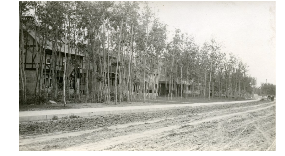
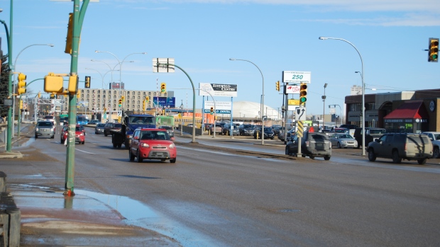
Idylwyld Drive is many things to Saskatoon and Saskatonians. It’s the gateway to the city from the airport and the North to the downtown. It’s the physical and psychological dividing line of the West side from the rest of the city. It’s the only highway that cuts through the middle of neighbourhoods and downtown and its construction heralded the end of the railway era and the primacy of the automobile one in the city.
In the next few weeks we are going to publish a series of articles on the future of Idylwyld Drive. We’ll cover the current re-construction of Idylwyld Bridge and the urgency of improving the active transportation access as part of the project. We’ll report on the City’s Imagine Idylwyld Planning Process and, finally, imagine a future where the Idylwyld Freeway no longer exists.
Idylwyld Drive then …… and now
We’re gearing up our organization. If you are interested in being a part of Saskatoon’s only advocacy group for pedestrians and walkable, livable cities get in touch with us using the links in the sidebar on the left.
Some good news on funding of sidewalk infill from City Council’s Standing Committee on Transportation from the last two meetings: council has proposed allocating just over a million additional dollars to Active Pedestrian Controlled lights, sidewalk infill construction and other city walkability improvements.
Being an election year (thinking cynically), the councilors decided to raid the Traffic Safety Reserve fund (money from traffic cameras) to increase already existing funding to smaller pedestrian improvements such as crosswalks and curb extensions as well as allocating some money to the capital budget item for building sidewalk infill.
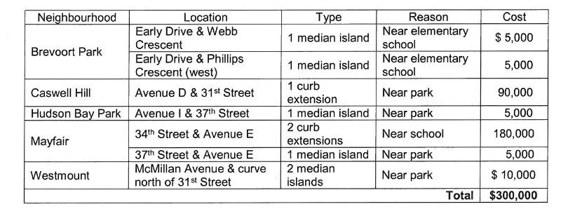
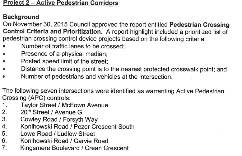
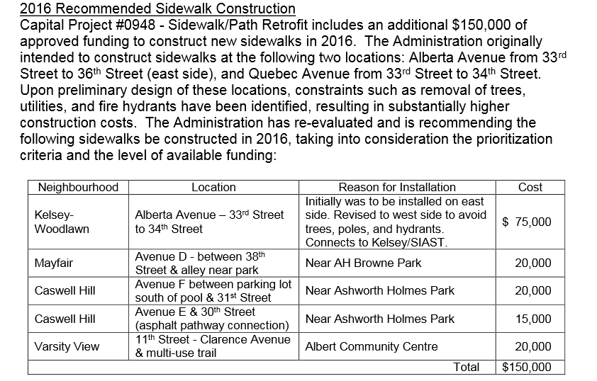
The big-ticket pedestrian items:
2016 proposed pedestrian safety improvementsProposed Pedestrian Crossing Controls 2016 (Top 4 funded)Proposed Additional Sidewalk Infill Construction List for 2016
Some thoughts:
The list of sidewalks to build is taken from a ‘priority list’ generated from Neighbourhood Traffic Reviews where at least the first priority is given to streets that are adjacent to schools and parks. How that priority list is further refined into the streets and neighbourhoods that got funded projects this year is not clear and probably involves some political calculus. Varsity View and Mayfair/Kelsey-Woodlawn had many requests approved and Haultain had none, for example.
It’s also not clear how this sidewalk infill priority list will differ from the sidewalk infill priority list contained within the yet-to-be-adopted Active Transportation Plan. Another issue with generating the list from Neighbourhood Traffic Reviews is that many areas have not had their reviews performed, making the infill list incomplete, and heavily biasing the improvement funding towards neighbourhoods that had their reviews earliest.
Priority lists of any sort are somewhat moot at this point in any case. Council has used all normally budgeted money for 2016 and 2017 as well as the one-time build-up from the Traffic Safety Fund to fund the listed work. In addition, earlier in the year there was $150,000 taken from the Active Transportation implementation fund allocated for sidewalk infill already in the budget (see below for list of projects) but it’s unclear if that money is budgeted in the future. Sidewalk infill needs are estimated to cost $4.2 Million 2016 dollars, and that’s just for the neighborhoods that have had traffic reviews. The real figure is probably twice as high. At $150,000 per year in the best case the holes in the walking network will take a long time to fill.
Already approved sidewalk infill in 2016.
However, it’s nice to talk about funded pedestrian improvements, hopefully this will be the first of many such announcements in the coming years.
The Kelsey-Woodlawn/Mayfair Local Area Plan, released last year, did a nice job capturing the needs of pedestrians in those neighbourhoods. The plan is full of great ideas, from sidewalk construction for the well-used routes around the SaskPoly parking lot and St. Michael’s school just off 33rd to traffic calming around area parks to ensuring that a pedestrian walkway is part of the proposed overpass at Airport Drive and Circle.
“The Full Saskatoon”: Alberta Avenue from 36th to 33rd; a park, a school and no sidewalks.
However, PDF documents full of good intentions have a hard time in Saskatoon instantiating themselves into physical changes. The Mayfair LAP itself talking about the impressive sounding ‘Priority 1 List’ of streets that need sidewalk installation, but sidewalk installation has no funding in the City’s budget, making any tiered designation farcical.
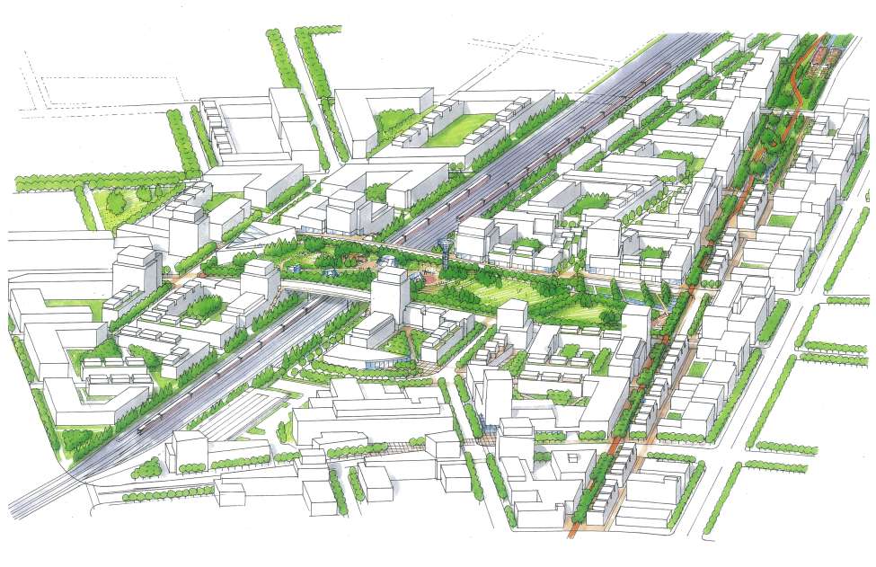
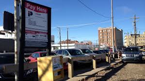
Another example of this disconnect between documents and reality happened recently when the City announced that the recently purchased rail line behind the Legion near 25th would be converted into a parking lot. This area was part of the proposed greenway areas in the North Downtown Master Plan. With the NDMP not anywhere near implementation this is not the worst idea in the world but it shows how long the cycle is to get any sort of pedestrian improvement finished, if ever.
North Downtown Linear Rail Trail PlanNorth Downtown Linear Rail Trail Reality